India is set to script another stellar chapter in its space exploration journey with the launch of the Space Docking Experiment (SpaDeX), scheduled for December 30, 2024, at 10:00:15 PM IST. This groundbreaking mission by the Indian Space Research Organisation (ISRO) underscores the nation’s growing prowess in cutting-edge space technologies.
Table of Content
- What is SpaDeX?
- Mission Objectives
- Docking mechanism
- Launch Details
- Spacecraft Development
- Hypothetical Instruments on the SPADEx Mission
What is SpaDeX?
SpaDeX is a pioneering initiative aimed at developing and demonstrating autonomous rendezvous and docking technology in space. This critical capability lays the foundation for ambitious future missions, including the establishment of an Indian Space Station and potential lunar endeavors like Chandrayaan-4.
The mission involves two sophisticated satellites, Chaser (SDX01) and Target (SDX02), each weighing 220 kg. These satellites will be launched into a 470 km low Earth orbit (LEO) aboard the trusted PSLV-C60 rocket.

Image from ISRO
Mission Objectives
1. Test autonomous docking technology for orbital operations.
2. Conduct proximity operations and controlled maneuvers for rendezvous.
3. Gather valuable data for future interplanetary missions and huma spaceflight programs.
Docking mechanism
The docking mechanism is a low-impact docking system (approach velocity is in the order of 10 mm/s), androgynous (docking systems are identical for both spacecraft, Chaser & Target), and is a peripheral docking system (concept similar to the International Docking System Standard used by other agencies for human missions). The mechanism is smaller (450 mm) with one degree of freedom for extension and uses two motors compared to the IDSS (800 mm) on a hexapod with 24 motors. Multiple test beds were established to test the hardware and software simulation of the docking kinematics to verify and finalise the docking approach parameters.
Why It Matters
Autonomous docking is a hallmark of advanced spacefaring nations. By mastering this capability, India joins an elite group comprising the USA, Russia, and China. The technology is pivotal for building modular space stations, resupplying orbital platforms, and assembling large space telescopes or interplanetary spacecraft in orbit.
The Journey of Chaser and Target
After deployment, the Chaser satellite will execute a series of intricate maneuvers to approach and dock with the Target satellite. The success of this experiment will validate the algorithms, sensors, and propulsion systems required for safe and precise in-orbit docking.

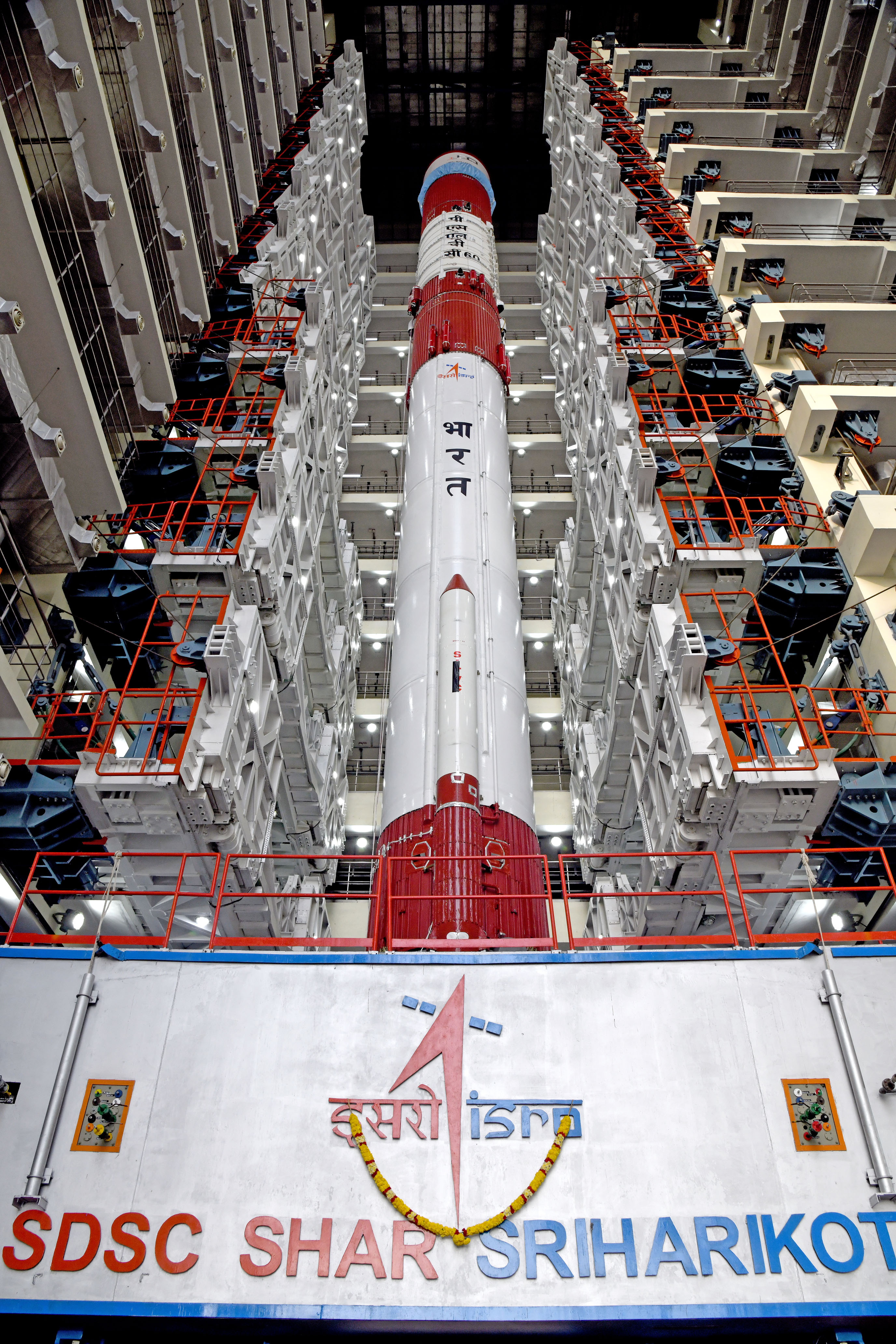
Launch Details
- Date & Time: December 30, 2024, at 10:00:15 PM IST.
- Launch Vehicle: PSLV-C60.
- Launch Site: Satish Dhawan Space Centre, Sriharikota.
- Live Coverage: The launch will be streamed live on ISRO’s official YouTube channel starting at 9:30 PM IST.
Spacecraft Development
The SpaDeX spacecraft were designed and realized by the UR Rao Satellite Centre (URSC) with the support of other ISRO centers (VSSC, LPSC, SAC, IISU, and LEOS). The spacecraft, in its orbital phase, will be controlled from ISTRAC using ISRO ground stations and other externally hired ground stations. The full integration and testing of the satellite were carried out at M/s Ananth Technologies, Bangalore, under the supervision of URSC. Presently, after completing all tests and clearances, the spacecraft has moved from URSC to SDSC and is undergoing preparations for launch.

All images from ISRO
Hypothetical Instruments on the SPADEx Mission
- High-Resolution Optical Cameras
- Function: These cameras would capture high-resolution images of Earth’s surface. They are used for mapping, land use monitoring, and disaster management.
- Role: These cameras can capture detailed images for urban planning, agriculture monitoring, and forest cover analysis.
- Synthetic Aperture Radar (SAR)
- Function: SAR systems are active radar-based instruments that provide detailed images of Earth’s surface, including through clouds and at night.
- Role: SAR would be crucial for continuous monitoring of the Earth’s surface, especially in regions with persistent cloud cover or low visibility. It helps in monitoring land subsidence, coastal erosion, deforestation, and disaster damage (e.g., after earthquakes or floods).
- Multispectral Sensors
- Function: These sensors capture data across different wavelengths of light, including visible, infrared, and near-infrared bands.
- Role: The data from multispectral sensors would be useful for vegetation health monitoring, land and water resource management, and environmental monitoring (e.g., detecting pollution, soil moisture levels).
- Thermal Infrared Sensors
- Function: These sensors measure infrared radiation from Earth, which is related to surface temperatures.
- Role: These instruments would help in monitoring heat patterns, which could be useful for detecting wildfires, studying the urban heat island effect, and monitoring ocean currents and temperature variations.
- Atmospheric Sensors (LIDAR, Spectrometers)
- Function: LIDAR (Light Detection and Ranging) and spectrometers are used to study atmospheric properties like cloud cover, pollutants, and aerosols.
- Role: These sensors would help track air quality, greenhouse gas levels, and other atmospheric components that affect climate and weather patterns. LIDAR would also be useful for measuring altitude and surface topography.
- Global Navigation Satellite System (GNSS) Payload
- Function: This system would help enhance the accuracy of GPS signals, providing precise location data.
- Role: It could be used for applications that require high-precision navigation, such as in agriculture (precision farming), disaster management (tracking emergency services), and transportation.
- Radiometers
- Function: Radiometers measure the intensity of radiation (in the form of light or heat) coming from Earth.
- Role: These instruments would be used for climate studies, observing ocean temperatures, and detecting changes in the Earth’s radiative energy balance (which can provide insights into global warming).
- Communication Payloads
- Function: This includes communication systems that allow data transmission between the satellite and ground stations.
- Role: The communication system ensures that the data collected by the satellite can be efficiently transmitted back to Earth for analysis. It could include both direct-to-Earth (DTE) communication links and relay satellite capabilities.
- Data Processing and AI-based Systems
- Function: These systems would process the vast amount of data generated by the sensors using artificial intelligence and machine learning algorithms.
- Role: The AI systems would analyze the collected data in real time, enabling quicker decision-making and offering insights into climate patterns, agricultural productivity, or disaster impacts.
Looking Ahead
SpaDeX is more than just a technical demonstration; it represents India’s bold vision for the future. From enabling sustainable human spaceflight to deep-space exploration, the technologies tested in this mission will be cornerstones of India’s space program for decades to come.
As the countdown begins, the world watches with anticipation. SpaDeX is not just a mission—it’s a leap toward a future where India takes center stage in humanity’s quest to explore the cosmos.
Stay tuned to SpaceFunta for live updates and expert analysis of this historic mission!